Scientists Seek to Solve Oystercatcher Mystery – and You Can Watch Online

Oystercatchers are beautiful birds, but to biologists they are also a mystery waiting to be solved. And the solution will be gradually revealing itself online over the next couple of years.
Wildlife biologists are particularly interested in oystercatchers because they are a good indicator species for determining whether a natural space is being well managed. The species usually nests on the open beach, just above the high water mark, making them subject to human disturbances, introduced predators (such as cats and dogs), and habitat loss due to development or coastal erosion.
Over the past 10 years or so, researchers conducted studies up and down the east coast of the U.S. that have revealed a great deal about oystercatcher migratory patterns. We now have a good idea of sites where they breed (e.g., coastal North Carolina) and where they spend their winters (e.g., coastal Florida). But we know virtually nothing about how they get from place to place. It’s one of nature’s mysteries.
What routes do oystercatchers take when traveling from their breeding grounds to their winter homes, and where do they stop to rest and eat when they’re en route? These are important questions, because the answers could tell us about the pressures facing oystercatcher populations.
For example, if the places oystercatchers use to rest and replenish their energy are being developed, that could have a significant impact on oystercatcher populations. And oystercatcher populations are not all that large – there are only five thousand to six thousand breeding pairs on the Atlantic coast.
Researchers from NC State University and Audubon North Carolina have embarked on a project to solve this mystery, using satellite tags. The tags, which weigh 9.5 grams, look like small backpacks – and the researchers plan to strap six of them onto adult oystercatchers to track their movements. The satellite tags communicate with orbiting satellites to measure the Doppler shift in their radio transmissions and determine the oystercatchers’ location to within 250 meters. The tags will give researchers a fix on their location about every two days, allowing scientists to see how the oystercatchers get from point A to point B during their seasonal migrations.
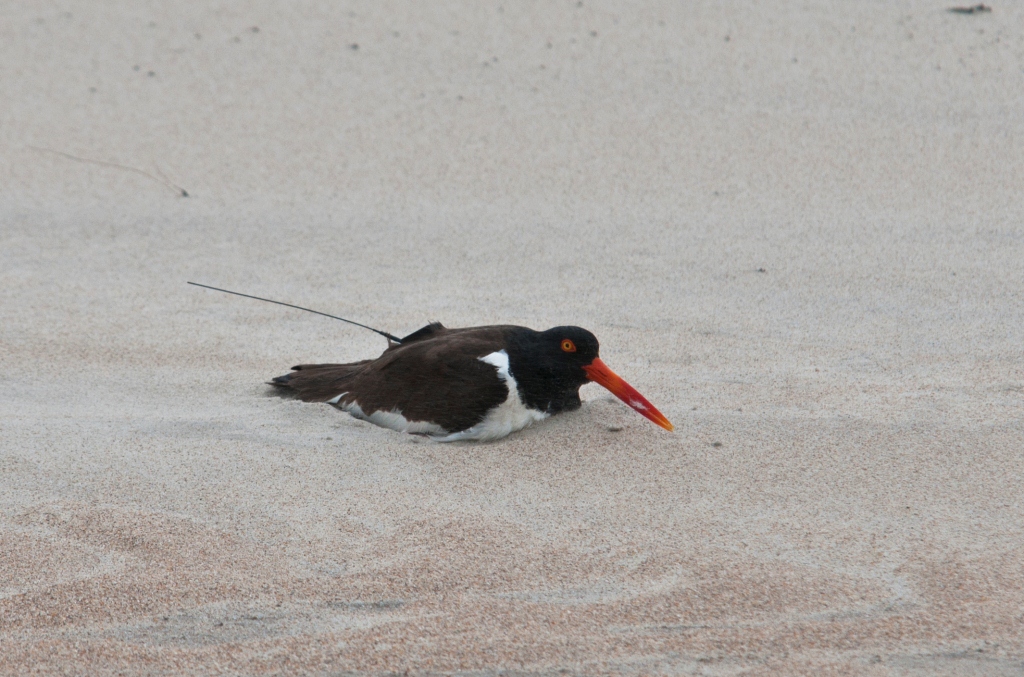
The researchers have put these tiny transmitters on five birds since April, and hope to tag one more bird in the coming weeks. The transmitters have an expected operating life of three years, but the researchers plan to trap the birds after two years and remove the tags. Support for the project comes from Together Green and the National Fish and Wildlife Foundation.
And the public will be able to watch along with the researchers, as the satellite tags shed light on the mystery of oystercatcher migrations. Audubon North Carolina has created a site, oystercatchertracking.org, that allows anyone to follow the movement of these birds – as well as offering additional information about the lives of the study subjects, such as whether their nests succeed, or when their chicks fledge.
“It’s a compelling story for environmental education,” says Ted Simons, a biology professor with the USGS Cooperative Fish and Wildlife Research Unit at NC State who’s participating in the research effort. But Simons is hoping that it is only part of the story.
While the satellite tags can give researchers data on how the oystercatchers move on a large scale, Simons is hoping that the technology will improve to a point that will enable him to track the birds in a more detailed way. Specifically, he wants to be able to track oystercatcher feeding behavior around their breeding grounds.
Over the past 20 years, some oystercatchers have begun nesting on “spoil islands,” which are created when dredging operations used to improve navigation dump the dredged “spoil” into great piles in the Albemarle Sound or in other waters on the western side of North Carolina’s Outer Banks.
These islands have fewer predators and less human disturbance than the beaches where oystercatchers traditionally nest, but they pose new challenges. The steep slopes of these spoil islands don’t offer good foraging habitat for oystercatchers, because they don’t have the broad beaches that are home to the invertebrate species oystercatchers feed on. As a result, oystercatchers have to fly to marshes on the mainland or barrier islands in order to find food for themselves and their offspring.
Simons is anticipating that GPS tags will soon be small enough for birds like oystercatchers. These tags will allow researchers to track the fine scale movements of birds to measure the energetic tradeoffs of living in different environments.
So if you decide to track the progress of the migratory mystery, stay tuned. As the technology advances, the oystercatcher researchers may put out a sequel.