Water Flow: A Picture’s Worth More Than A Thousand Words

- Sometimes a picture can save time and money — and that’s worth more than a thousand words.
From mitigating flood damage to managing water resources during a drought, tracking water flow is important. But tough budget times make maintaining data collection systems more difficult than ever. Researchers may have found a way to ease the problem, using a remote imaging system called GaugeCam.
Government officials track so-called streamflow, or the rise and fall of water levels, to make informed decisions about water use for everything from drinking water supplies to agricultural demands to environmental protection. Streamflow data is also tracked to provide early warning of flooding, erosion or other threats to life, property and infrastructure. And this information is becoming increasingly important, as climate change is predicted to contribute to increased instances of drought and flooding.
But the equipment used to collect and transmit data from remote locations needs to be maintained. That can be problematic when budgets are tight. Technicians are often located in central offices, hours away from the data collection systems. Those technicians might be able to tell that something is wrong, but don’t have any way of determining what has happened without traveling to the remote site.
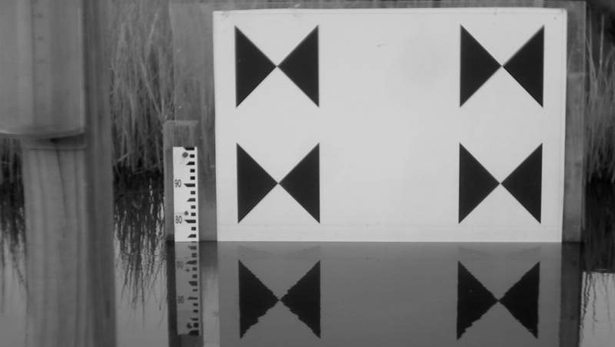
That’s where GaugeCam can come in. “We wanted to explore the possibility of using wireless imaging technologies to help track water flows in streams and rivers,” says François Birgand, a biological engineering researcher at NC State who led the development of GaugeCam. “GaugeCam uses a remote camera that takes an image as often as every five minutes, day and night, and uploads that image to a server,” Birgand says. “Because the camera is set up to take photos of a target background [see image above], the GaugeCam software program can automatically scan the image to determine the water level and post that value online. The image itself is also available, so you have a way to verify the data.” And, because a picture is worth a thousand words, technicians can use the image to troubleshoot any potential problems.
For example, if there is a sudden upward spike in water level, technicians can go to the image to see whether there was an actual surge, or if the data collection equipment itself was knocked askew by wildlife or otherwise tampered with. “Technicians essentially have the same visual information they would have if they were in the field, but it is available in their office and is updated every five minutes, so can save a lot of money and effort,” Birgand says.
The GaugeCam system is powered by a solar panel, and requires significantly less maintenance than traditional monitoring equipment.
Birgand’s team has operated a pilot GaugeCam system in a restored marsh in coastal North Carolina for six months. However, they designed the software and online server to have capacity for hundreds of additional units.
Birgand says next steps for GaugeCam include generating an alarm that can be used to notify authorities when there is the potential for flooding. Birgand’s group also plans to create a program that would use GaugeCam to trigger actions in the field based on water level data – such as opening or closing an irrigation gate or starting an irrigation pump – to better manage water flow. All of this is available on smartphone technologies.
“This technology could also be used in developing countries, in areas where general maintenance skills are low,” Birgand says. “Maintenance for this system is fairly easy – all you have to do is scrub the target background and clean the lens.”
- Categories:


